STORM WATCH: Mix of rain and snow for Connecticut Sunday with accumulations of 1-3 inches
News 12 Storm Watch Team Meteorologist Michele Powers says parts of Connecticut could see a wintry mix of snow on Sunday with accumulations between 1 and 3 inches.
•
Dec 10, 2022, 12:48 PM
•
Updated 637 days ago
Share:
More Stories
2:26

The best time of the year to view Saturn is on Sunday when the planet will be in opposition
21h ago1:39

Why has hurricane season quieted down?
yesterday2:30

Goodbye to summer 2024
7ds ago
LIVE BLOG: News 12 weather updates
10ds ago1:04

Cooler temperature trend into start of meteorological fall
10ds ago1:06

Naugatuck farmer impacted by recent flooding discusses state grant for emergency assistance
10ds ago2:26
The best time of the year to view Saturn is on Sunday when the planet will be in opposition
21h ago1:39
Why has hurricane season quieted down?
yesterday2:30
Goodbye to summer 2024
7ds agoLIVE BLOG: News 12 weather updates
10ds ago1:04
Cooler temperature trend into start of meteorological fall
10ds ago1:06
Naugatuck farmer impacted by recent flooding discusses state grant for emergency assistance
10ds agoNews 12 Storm Watch Team Meteorologist Michele Powers says parts of Connecticut could see a wintry mix of snow on Sunday with accumulations between 1 and 3 inches.
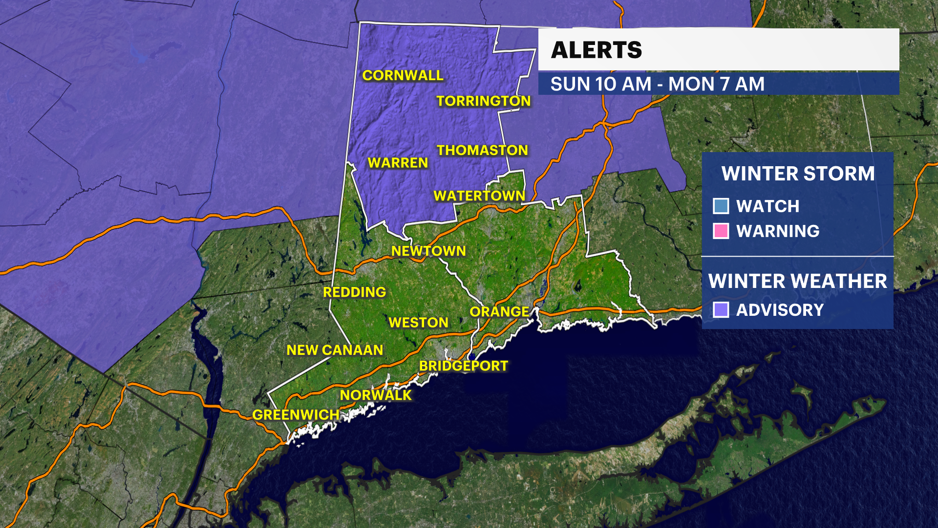
The National Weather Service has issued a winter weather advisory for Litchfield County from Sunday morning through Monday morning.
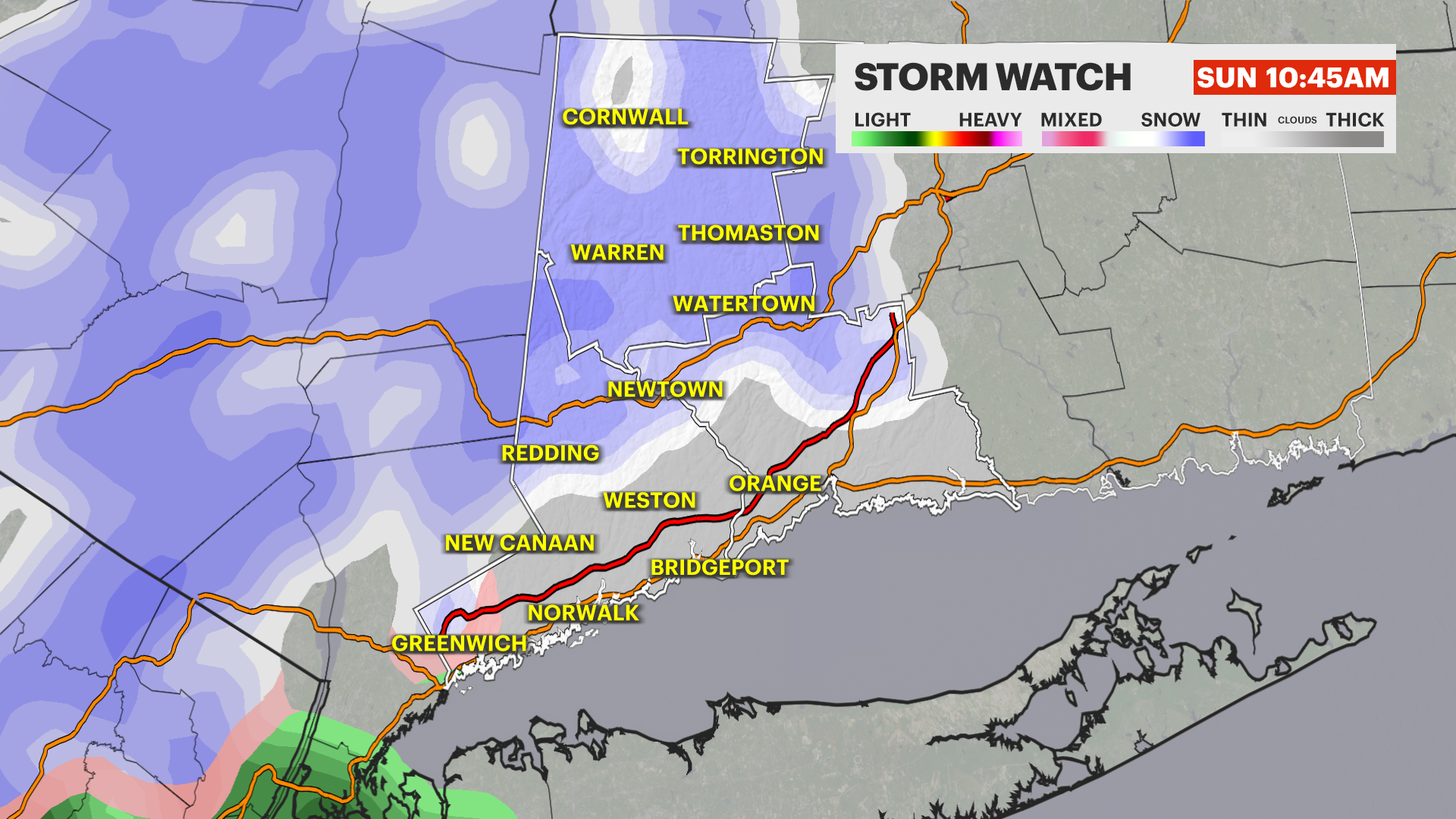
WHAT'S NEW: Tracking the system for Sunday and with colder air in place, it looks cold enough to see some wintry weather fall.
There will be some minor accumulations south and mainly on colder surfaces first. Closer to the I-95 corridor up through the Merritt Parkway will see very little, possibly a coating up to 1 inch. There will be some rain mixing in in this part of the state as well.
Further north and up in elevation could see between 1 to 3 inches in Northern Fairfield County and north of I-84, about 3 to 5 inches or even a few spots at 6 inches in northern Litchfield County.
WHAT'S NEXT: Slippery conditions are expected on the roads overnight into Monday morning as temperatures fall everywhere.
Temperatures continue to stay colder this whole week.
Next storm system comes Thursday into Friday.
FORECAST
SATURDAY: Chilly with clouds increasing throughout the day. Highs around 40, but it will feel like the 30s.
OVERNIGHT: Cloudy with snow moving in for the morning. Lows around freezing.
SUNDAY: Highs around 40 and lows around freezing. Snow and rain mix for lunchtime. The heaviest snow arrives in the evening and will last overnight.
MONDAY: Lingering snow shower, mix or rain. Clears in the p.m. Highs around 40 and lows in the 20s.
TUESDAY: Sunny sky. Highs around 40 and lows in the 20s.
WEDNESDAY: Mostly sunny with highs around 40 and lows around 30.
THURSDAY: Mostly cloudy with a chance of a rain/snow mix. Highs around 40 and lows in the 30s.
FRIDAY: Mostly cloudy with a rain/snow mix possible. Highs around 40 and lows around freezing.
SATURDAY: Mostly cloudy with highs around 40 and lows in the 30s.
More from News 12
1:37

‘Community Rising’ music festival raises funds for CT residents impacted by historic flooding
2:19

Chilly morning, pleasant afternoon Sunday in Connecticut
0:33

Norwalk police: 2 juveniles stabbed at Norwalk Oyster Festival; arrest made
0:55

Stamford PD: Student who threatened to ‘shoot up the school’ on Snapchat arrested
1:05

Stratford boxer takes on 2nd professional bout at Foxwoods
0:43
