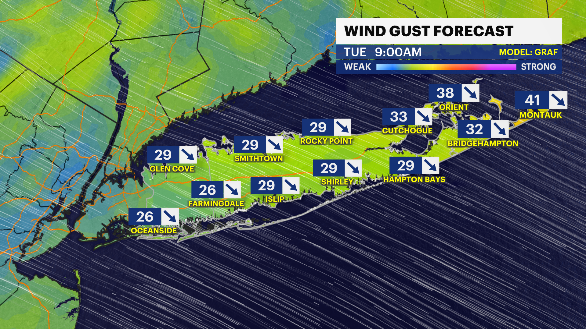
Gusty wind returns to Long Island this week, but with little rain
Mostly clear overnight, but with a stronger wind that can gust higher than 30 mph at times through the first half of Election Day.
Share:
More Stories
1:55

Breezy sunshine & seasonable temperatures for Election Day
11h ago2:15

Bridgeport’s Jamaican community reacts to Hurricane Melissa heading to their homeland
7ds ago1:55

Warm weather lingers in Connecticut; cooler air arrives midweek
29ds ago
News 12 weather blog
31ds ago1:55

Pleasant stretch of weather ahead in Connecticut
50ds ago1:55

Hot and humid stretch looms for Connecticut
85ds ago1:55
Breezy sunshine & seasonable temperatures for Election Day
11h ago2:15
Bridgeport’s Jamaican community reacts to Hurricane Melissa heading to their homeland
7ds ago1:55
Warm weather lingers in Connecticut; cooler air arrives midweek
29ds agoNews 12 weather blog
31ds ago1:55
Pleasant stretch of weather ahead in Connecticut
50ds ago1:55
Hot and humid stretch looms for Connecticut
85ds agoAfter some showers on Monday, it is drier overnight, but with some gustier wind. This is not damaging wind, but it could wake you up overnight with some gusts briefly higher than 30 mph.
Have a heavier coat in the morning. The wind will make for a chilly start on Election Day. The entire day will look great with a mostly sunny sky and highs around 60 degrees in the afternoon despite a gusty breeze that will start to diminish after around 3 p.m.


Temperatures this week will stay in the upper 50s to low 60s. The normal average high in early November on Long Island is 56 degrees.

The wind will subside starting mid-afternoon Tuesday and will be lighter into Wednesday morning before increasing again for Wednesday afternoon and evening.

Most of the week is dry! In fact, other than a quick shower Wednesday night, scattered showers hold off until late Friday night into Saturday.
Our next full "supermoon" can be seen between Tuesday and Wednesday of this week. November's full moon is called the Beaver Moon because it is the time of year that beavers build their homes for the upcoming winter. The fact that it is the second in a succession of four "supermoons" just means it will appear slightly larger and brighter than usual.

FORECAST:
OVERNIGHT: Mostly clear, windy and colder feeling. Wind: northwest 15 to 25 mph with some gusts 25 to 40 mph. Lows near 45 degrees. It can feel like the 30s in spots early Tuesday morning.

TUESDAY: ELECTION DAY — Mostly sunny with a few passing afternoon clouds. Noticeably windy, but dry. Highs around 60 degrees. Wind: northwest 15 to 25 mph with some higher gusts can be in the 30 to 40 mph range. Lows near 43 degrees.

WEDNESDAY: BECOMING WINDY AGAIN (PM) — Sun and clouds. There will still be a lull in the wind in the morning, but the wind picks back up in the afternoon and evening. This will likely be the strongest wind of the week for Wednesday evening and through the overnight hours. A few gusts can be between 40 to 50 mph. Highs around 63 degrees. A brief rain shower is possible in the mid to late evening hours. Lows near 45 degrees.

THURSDAY: Becoming mostly sunny. Still a bit windy. Wind: northwest around 15 to 30 mph. Highs around 57 degrees. Lows near 40 degrees.
FRIDAY: Cold start in the early morning. Partly sunny. Highs around 62 degrees. Lows near 50 degrees.
SATURDAY: Chance for scattered rain showers, especially in the morning. Mostly cloudy. The entire day should not be a washout. Highs around 62 degrees. Lows near 45 degrees.
SUNDAY: Early breaks of sun. Then, becoming mostly cloudy with a few showers late in the day. Highs around 57 degrees. Lows near 41 degrees.
MONDAY: Mostly cloudy. Much cooler. Highs around 50 degrees. Lows near 33 degrees. This could be our coldest night of the season yet.
TUESDAY: VETERANS DAY — Mostly sunny and chilly with highs around the mid to upper 40s. Lows near 37 degrees.

More from News 12
1:55
Breezy sunshine & seasonable temperatures for Election Day
0:26

Optimum offering free calls, texts from the US to Jamaica due to Hurricane Melissa
2:15
Bridgeport’s Jamaican community reacts to Hurricane Melissa heading to their homeland
2:14

Nor’easter causes thousands of power outages across Connecticut
1:57

Thunderbolt 12: Checking out conditions in Bridgeport amid strong nor’easter
2:22
