More Stories

A minor winter storm is going to bring snow and a messy wintry mix to the tri-state area on Tuesday.
A wintry mix usually is a combination of two or three types of frozen precipitation. These are snow, sleet and freezing rain. But have you ever wondered what the difference is between the three? Let's take a closer look.
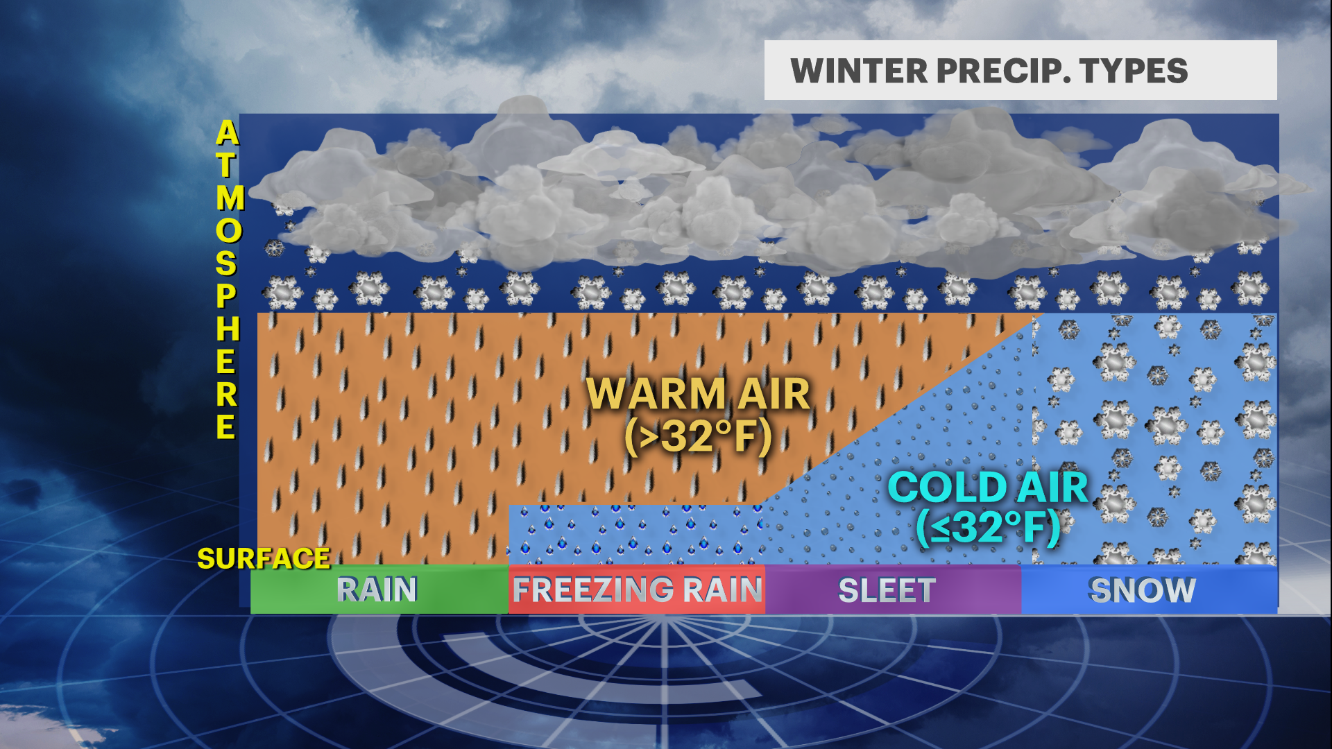
 The vertical temperature profile of the atmosphere is what will dictate what form the precipitation reaches the ground in.
High up in the atmosphere, the air is well-below freezing - and so snow is falling from the clouds. At that point, four different things can happen:
- The air is cold enough all the way down to the surface, so the snow will reach the ground.
- The snowflakes encounter a warmer layer of air (above freezing) causing them to melt into raindrops. The air then drops below freezing again well-before the rain reaches the ground, so the drops refreeze into what we call sleet pellets - tiny balls of ice that will "dink" and bounce off of whatever they hit. (Ever hear a friend say "Hey, it's hailing!" during the winter? Now you can correct them!)
- The snowflakes encounter a warmer layer of air, causing them to melt into raindrops. The air remains above freezing until the rain is close to the ground, where it then quickly drops below freezing. The rain droplets then become "supercooled," meaning they fall below 32 degrees yet remain in the liquid state. As soon as they reach the surface, they then freeze onto whatever they come in contact with (roads, trees, houses, etc.) This is what happens in ice storms and can be even more dangerous than a snowstorm.
- The snowflakes encounter warmer air, and the air stays above freezing all the way to the ground, giving us rain.
During a winter forecast, meteorologists using the "mixing" word is a nightmare for snow lovers - for those who loathe snow, this is typically good news. Much of our area is subject to this as we are close to the relatively warmer ocean water. Long Island, New York City and the Jersey Shore are the likeliest candidates, but depending on the track of the storm, it can happen anywhere.
More from News 12
1:27

Thunderbolt 12 tracks severe thunderstorms and floods in Fairfield County
2:09

Sunrise solar eclipse is Thursday – everything you need to know!
1:50

Turning waste into watts a boon for environment

Super Flower Blood Moon: When and where to see it

NOAA's 2021 hurricane season forecast sees another busy season in the tropics
1:01
