Less humid & more sunshine today, storms return later tonight
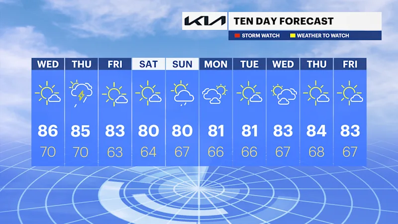
It's hot and less humid today with stray storms returning for Thursday. If you have weekend plans, Saturday will be the pick. Storms could return Sunday.
More Stories


What to Know
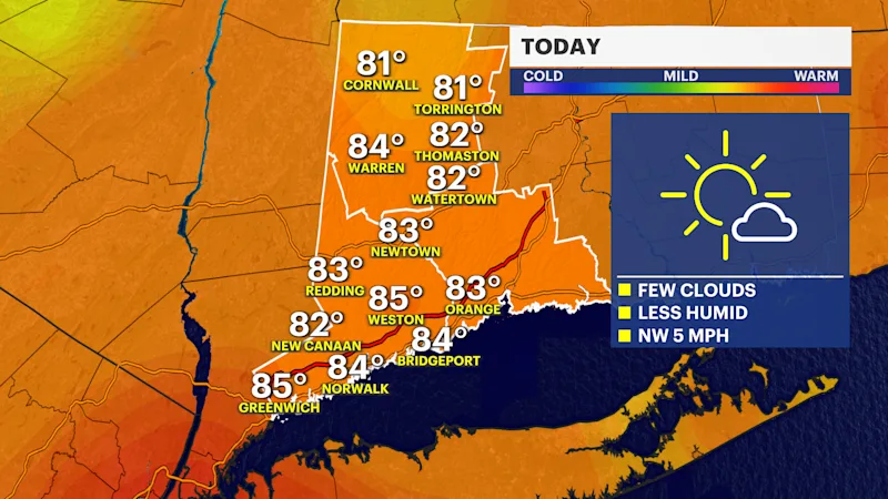
It's a hot day today with less humidity.
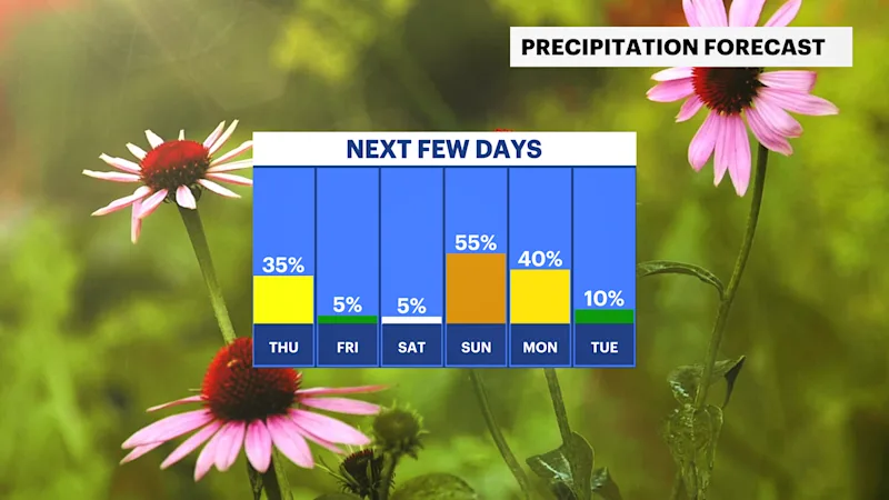
Spotty storms tonight and Thursday.
Gorgeous Friday and Saturday with sunny skies and highs in the low 80s.
Rain chances creep back in by Sunday and look more likely Sunday night into Monday.
Morning Rush
Clouds will still be hanging around as you head out the door, with morning temperatures in the 70s. There's only a small chance of a passing shower early and skies are clearing out so you won't need the umbrella. Winds stay light out of the north.
Rest of Wednesday
Skies clear out through the afternoon, turning mostly sunny for the afternoon. Highs climb to the upper 80s, making it the warmest day of the week. Humidity stays manageable and winds stay light, so it should feel like a solid summer day overall. Keep in mind that late tonight, showers and a few thunderstorms become possible, mainly overnight, as a weak front moves through.
Also worth knowing tonight: an approaching new moon is pushing tides higher than normal, and some minor coastal flooding is possible along low-lying parts of the Fairfield County shoreline during the overnight high tide.
Thursday
A few lingering showers are possible in the morning, then another round of showers and thunderstorms could develop in the afternoon. Overall, most of the day stays dry with mostly sunny skies, and highs reach the upper 80s. Any storms that do form should move through quickly. The same higher tides linger into Thursday night, so another round of minor splashover is possible in vulnerable spots along the Sound.
Friday
Friday looks great. Mostly sunny skies and a high in the low 80s make it a comfortable day with much lower humidity than earlier in the week. It's good timing if you're headed to the Milford Oyster Festival on the Sound, which wraps up its two day run on the Green.
The Weekend
Saturday is the standout, with sunny skies and a high in the low 80s, another solid day for the tail end of the Oyster Festival or any other waterfront plans. Sunday starts off mostly sunny too, but a chance of showers moves in during the afternoon. Rain becomes more likely Sunday night, so outdoor evening plans may need a backup.
Boat and Beach
Long Island Sound stays calm enough for boating through the weekend, with no major wind or wave concerns expected out of Norwalk, Stamford, or Greenwich harbors. If you're headed to Compo Beach, Sherwood Island, or Greenwich Point, the rip current risk is generally low through Thursday, though the widening tidal swing from the new moon means it's worth being a bit more careful swimming around each afternoon's low tide, especially heading into the weekend.