2026 hurricane season now underway. Here’s what to expect.
It appears this upcoming tropical season might not be as active. There are a few climate and weather features that might suppress tropical systems from developing.
More Stories


The National Oceanic and Atmospheric Administration (NOAA) has made a preliminary forecast about the current hurricane season.
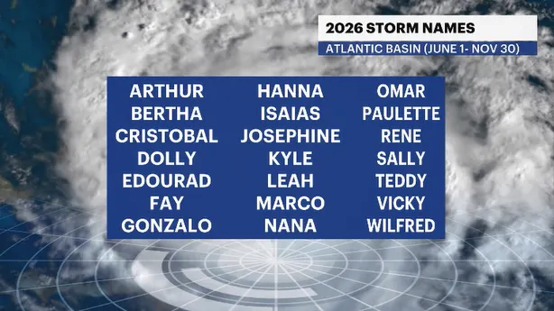
You’ll notice a familiar name on the list again this year - ”Isaias.” For the life of me, I am still not quite sure why the World Meteorological Organization didn’t retire “Isaias” after what that storm six years ago did to the Tri-State area.
I have some good news, and I have some bad news.
First, the good news. It appears this upcoming tropical season might not be as active. There are a few climate and weather features that might suppress tropical systems from developing.
One big clue to the forecast in the Atlantic Basin is occurring in the Pacific. A very, and I mean very large El Niño is developing. This phenomenon usually creates a weather pattern in the Atlantic that typically shears any tropical system from reaching its full potential or caps development altogether.
During El Niño years, the rainy season in the western half of Africa is in full swing. Those storms kick up an unusual amount of dust from the desert regions and that plume of Saharan dust drifts off into the western Atlantic, where our typical big hurricanes come from. The dust itself doesn’t allow storms to develop and is one of the mitigating factors in lesser storms being forecast.
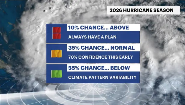
Now the bad news. The chance of a storm is not zero. From Wildwood to Westhampton, Sag Harbor to Stamford, New Rochelle to Newton, it is always worthwhile to have a plan in place. It only takes one storm to make for a very bad season.


