HEAT ALERT: Potential heat wave for NYC this workweek
Storm Watch Team Meteorologist Hope Osemwenkhe says New Yorkers can look ahead to a possible heat wave this week, with chances for record-setting temperatures ahead.
News 12 Staff
•
Aug 1, 2022, 9:37 AM
•
Updated 640 days ago
Share:
More Stories
1:39
Warm and dry temps for Connecticut; cooler weekend expected
2h ago1:06

LIVE BLOG: News 12 weather updates
16h ago
Ready to explore the great outdoors? These 14 tips can help you stay safe while hiking
7ds ago2:16
Cold and sunny for Thursday; frost possible at night
8ds ago2:16
Chilly temperatures overnight in Connecticut, scattered shower returns on Wednesday
9ds ago2:16
Temperatures drop overnight, more sunshine for Connecticut on Tuesday
10ds ago1:39
Warm and dry temps for Connecticut; cooler weekend expected
2h ago1:06
LIVE BLOG: News 12 weather updates
16h agoReady to explore the great outdoors? These 14 tips can help you stay safe while hiking
7ds ago2:16
Cold and sunny for Thursday; frost possible at night
8ds ago2:16
Chilly temperatures overnight in Connecticut, scattered shower returns on Wednesday
9ds ago2:16
Temperatures drop overnight, more sunshine for Connecticut on Tuesday
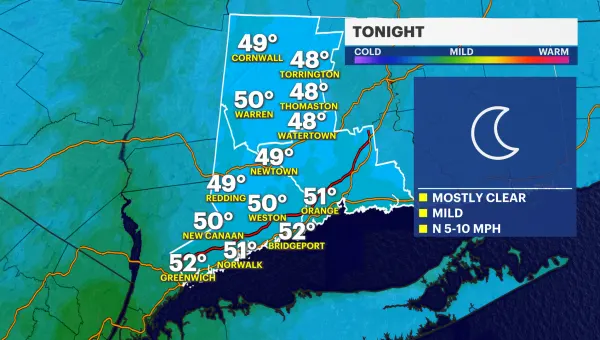
10ds agoNOW: Overnight humidity increase leads to temperatures to be in the 90s on Tuesday.
NEXT: Hottest day this week will be on Thursday. Temps have the potential to reach the mid- to upper-90s. A record-high of 99 degrees set back in 1944 is possible. A frontal system will pass our area on Friday, and this may bring temps down a bit. There is a threat for T-storms as of now.
Storm Watch Team Meteorologist Hope Osemwenkhae says New Yorkers can look ahead to a possible heat wave this week, with chances for record-setting temperatures ahead.
OVERNIGHT: Partly cloudy sky with warm temps. Humid Lows near 74. SE- wind 5-10 mph.
TUESDAY: HEAT ALERT Sunny with high thin clouds, hot and muggy. Chance of isolated storms. Highs near 91. Lows near 74.
WEDNESDAY: HEAT ALERT Still hot, sunny, and not as humid. Highs near 90. Lows near 75.
THURSDAY: HEAT ALERT Dangerously hot and steamy. Feels like 100-105 degrees. Highs near 96. Lows near 78.
FRIDAY: POSSIBLE HEAT ALERT Mostly sunny and very hot and muggy. Chance of storms. Highs near 89. Lows near 75.
SATURDAY: Mix of sun and clouds, warm and humid. Chance of storms. Highs near 85. Lows near 74.
SUNDAY: Mostly sunny and warm. Highs near 87. Lows near 73.