How to stay safe during Tuesday's Fire Weather Warning
After the worst air quality since June 2023 this past weekend, another round of dangerous fire weather could bring similar if not worse conditions to the city.
Share:
More Stories
1:43

Winter solstice to arrive this weekend
9ds ago1:25

Thunderbolt 12 checks out snow cleanup efforts in Newtown
10ds ago1:45

Thunderbolt 12: Fairfield County
15ds ago1:44

Best time to view Jupiter in opposition
21ds ago1:24

Winter Weather Outlook: How will this upcoming winter shape up?
29ds ago1:06

Storm Watch: Will the Macy's Thanksgiving Day Parade be a washout?
30ds ago1:43

Winter solstice to arrive this weekend
9ds ago1:25

Thunderbolt 12 checks out snow cleanup efforts in Newtown
10ds ago1:45

Thunderbolt 12: Fairfield County
15ds ago1:44

Best time to view Jupiter in opposition
21ds ago1:24

Winter Weather Outlook: How will this upcoming winter shape up?
29ds ago1:06

Storm Watch: Will the Macy's Thanksgiving Day Parade be a washout?
30ds agoThe Storm Watch Team has been alerting about the dangerous fire and air quality concerns since last week, and Tuesday's conditions may be the most dangerous of this stretch.
The four key ingredients that have contributed to over 100 brush fires in New York City in the last 10 days are still present.

— Gusts of 20 to 30+ mph
— Very low humidity
— Direct sun
— Dry ground
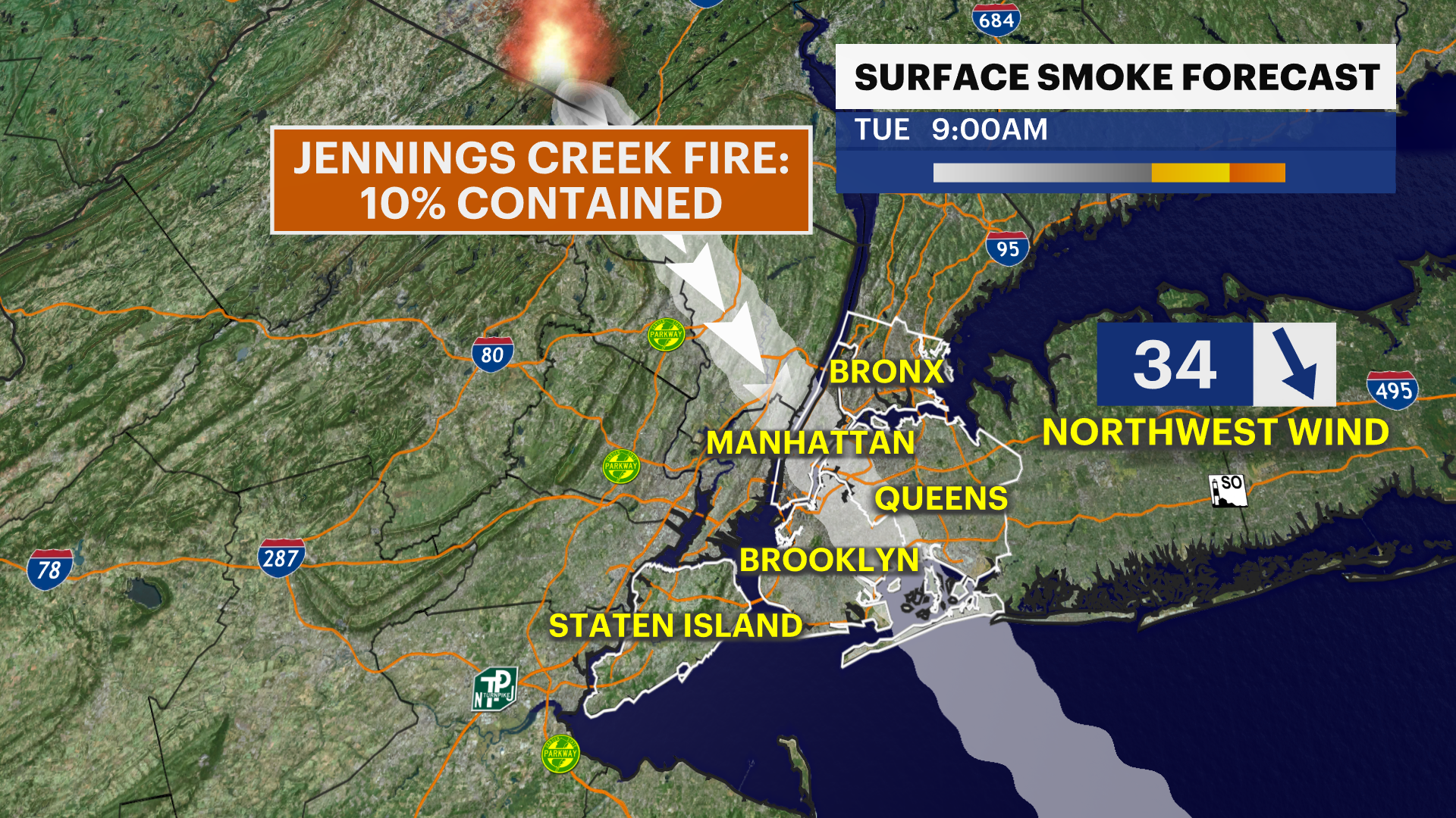
This will continue to keep the risk of brush fires and explosive fire growth high. Even with the sun down at night, the other three ingredients are still in place overnight Monday night and parts of Tuesday night. Even if there are no major new fires inside New York City, there is one major wildfire about 30 miles northwest of the city that will bring the wildfire smoke and dangerous air quality for Tuesday morning's commute. The Jennings Creek Wildfire is only 10% contained as of Monday evening and has spread across thousands of acres. The large and hazardous plume of wildfire smoke has brought dangerous air quality most of this past weekend, and the wind will once again align to send that hazardous plume back down after 6 a.m. Tuesday. Depending on the exact wind direction and intensity of the wildfire, air quality could become unhealthy again.

It is important to keep yourself and loved ones safe. If you smell smoke, close your windows. The wind blows the smoke into buildings, and it is then trapped inside. Wear a mask outside. Inhaling smoke could invoke headaches, so it is important to listen to your body, and take it easy if you feel symptoms.

Do not forget to bundle up if needing to go outside. It will be chilly during the day with feels like temperatures in the 40s, and downright cold at night with feels like temperatures in the 20s for the first time this season. The fire risk will be diminished on Wednesday with lighter wind, but it will still be bone dry through this weekend. A cold front will likely miss the area on Thursday. Stay tuned with Allan and the Storm Watch Team for updates.

More from News 12
2:28

Rainy weekend ahead for Connecticut
2:28

BITTER BLAST: Frigid temperatures for Monday; tracking overnight light snow for Connecticut
1:23

Is your car winter ready? What to check under the car hood
1:43

Winter solstice to arrive this weekend
2:28

STORM WATCH: Rain overnight kicks off wet weather week in Connecticut
1:45
